What's New
Bug fix...
Bug fix...
Size:
Category:
Navigation
Navigation
OS:
iOS
iOS
Price:
Free
Free
Compatible:
iPhone
iPhone
Requirements:
Compatible with iPhone
Compatible with iPhone
Version:
2.6
2.6
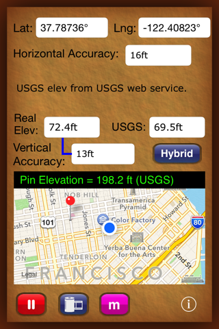
Description - Elevation For Real
.
The Elevation For Real is now available as a free download on Apple Store for iPhone owners. The application is supporting English language. It weighs in at only 10MB to download. It is highly advisable to have the latest app version installed so that you don`t miss out on the fresh new features and improvements. The current app version 2.6 has been released on 2014-11-16. For ensuring consistency with the device you should take into account the following app compatibility information: Compatible with iPhone and iPod touch. Requires iOS 4.0 or later.
More Info: Find more info about Elevation For Real in homedatasheet.com, Inc.`s Official Website : http://www.homedatasheet.com
More Info: Find more info about Elevation For Real in homedatasheet.com, Inc.`s Official Website : http://www.homedatasheet.com
Ever wonder why the "altitude" reading on your iPhone 3G or 3GS never seems to correspond to your elevation above sea level? It's because altitude and elevation are measures of two different quantities. Elevation For Real ...
I ve only use this app a short time for search Rescue It s a great app Works very well Great Trainman2
I use this app at construction sites to verify the elevations of deferent areas and it does the job Thank you Accurate and it does the job Ned Scuba_bk
The elevation reported is very accurate Also unlike most other elevation apps this one displays an uncertainty tolerance and identifies the digital elevation darabase it uses Excellent MAF
This is the most accurate elevation app I have found on the App Store Accurate revNickname41
What a great little app We re house hunting and want to know the elevation of the houses we look at This does the trick perfectly We can tell which homes are out of the tsunami danger zone Just what I wanted when I got the app Great app Novellen
This app did exactly what I wanted during my walks between sea level and 2750 ft elevation around Marin County in the San Francisco Bay area Within half a minute or so it told me what my elevation was with estimates from both the iPhone 3G GPS and the USGS database indexed by latitude and longitude With longer periods of sampling the two estimates generally converged within 20 ft or so even on mountain paths It is really a terrific addition to the phone complementing the main feature that the built in Maps for iPhone lacked V2 4 current free version works perfectly in Marin County California Michael SF
I just wanted an app that could tell me my current elevation It did exactly that Ran fine I have a Verizon iphone4 Good app Metdoc1
Hey these guys are super in creating this app This is not a toy This is a pro consumer app Great support Lots of uses and a great learning tool for school kids and curious folks Super Wingingit
I was looking for a simple app to show elevation at my current location and this does that nicely Not super accurate but wasn t expecting that Has a very nice user interface Great app can t beat the price DJRobX
I started this app for the first time indoors when the shades were closed It still worked They also explain why most other altimeters for the iPhone don t work properly Nice Well thought out app that does the job quickly Fgrider
Informative Fun to know mtoale
From the top of the mountain at Snowbird UT to the coast of NC this app is surprisingly accurate If you don t require pinpoint accuracy this free app is quite handy for those who are casually curious Surprisingly Accurate SLowery82
Works great for me fo sho Works Tpizzlewizzle
I read the reviews and was like this will waste my time But no I downloaded it and I love it It works perfectly It shows the same elevation somewhere as my google earth I mean for free you can t beat it Great Ben10parker
Shows that I am twice as high in tx than I was on a mountain in Colorado Must think I m in a plane Dr. Patient
I live right on the coast and the usgs seemed pretty close to being spot on the real elevation was horribly inaccurate showing me at an altitude of almost 300ft Please fix Needs work Toddep23
What a great little app Were house hunting and want to know the elevation of the houses we look at This does the trick perfectly We can tell which homes are out of the tsunami danger zone Just what I wanted when I got the app Great app
I live right on the coast and the usgs seemed pretty close to being spot on the real elevation was horribly inaccurate showing me at an altitude of almost 300ft Please fix Needs work
The elevation reported is very accurate Also unlike most other elevation apps this one displays an uncertainty tolerance and identifies the digital elevation darabase it uses Excellent
This app did exactly what I wanted during my walks between sea level and 2750 ft elevation around Marin County in the San Francisco Bay area Within half a minute or so it told me what my elevation was with estimates from both the iPhone 3G GPS and the USGS database indexed by latitude and longitude With longer periods of sampling the two estimates generally converged within 20 ft or so even on mountain paths It is really a terrific addition to the phone complementing the main feature that the builtin Maps for iPhone lacked V24 current free version works perfectly in Marin County California
This is the most accurate elevation app I have found on the App Store Accurate
What do real elevation usgs elevation and V accuracy mean My assumptions about what V accuracy means implies that this app is useless for real measurements I am at a real elevation of 350 ft 45 ft Is that really what v accuracy means A little more explication for the layman would be useful Wish there was more explanation
I started this app for the first time indoors when the shades were closed It still worked They also explain why most other altimeters for the iPhone dont work properly Nice Well thought out app that does the job quickly
Informative Fun to know
I just wanted an app that could tell me my current elevation It did exactly that Ran fine I have a Verizon iphone4 Good app
Shows that I am twice as high in tx than I was on a mountain in Colorado Must think Im in a plane
Works great for me fo sho Works
I read the reviews and was like this will waste my time But no I downloaded it and I love it It works perfectly It shows the same elevation somewhere as my google earth I mean for free you cant beat it Great
Hey these guys are super in creating this app This is not a toy This is a proconsumer app Great support Lots of uses and a great learning tool for school kids and curious folks Super
From the top of the mountain at Snowbird UT to the coast of NC this app is surprisingly accurate If you dont require pinpoint accuracy this free app is quite handy for those who are casually curious Surprisingly Accurate
I was looking for a simple app to show elevation at my current location and this does that nicely Not super accurate but wasnt expecting that Has a very nice user interface Great app cant beat the price
By Kostas Gar.